The Ottoman contribution to science and technology during their six hundred year rule is beyond measure. This article is a brief outline of just some of the Ottoman scientific activities and related institutions that brought about the revival of culture, science, and learning in civilization throughout the Islamic world and beyond. To instantiate the Ottoman scientific contributions, the author focuses on two significant examples from astronomy and geography in the 16th century: the foundation of Istanbul Observatory and Taqi Al-Din's achievements therein, map making and mapmakers such as the famous sailors Piri Reis, Saydi Ali Reis and Macar Ali Reis.
In its history and development, the innovative features of Ottoman science are obvious and various. Whilst the older Islamic centres of science and culture influenced initially Ottoman scientific tradition, it quickly reached a point where it could itself influence these old centres and serve as an example to them.
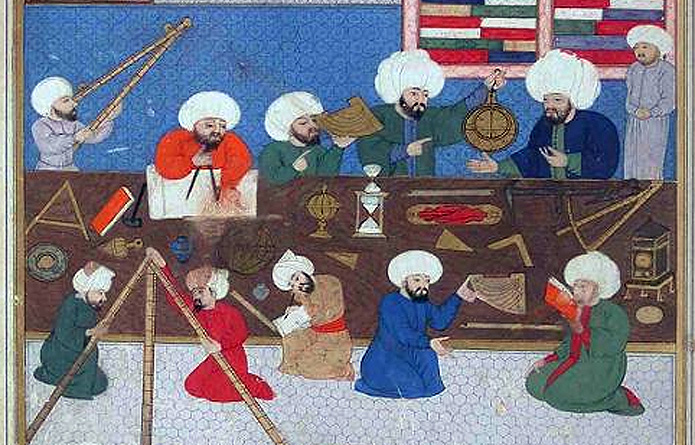
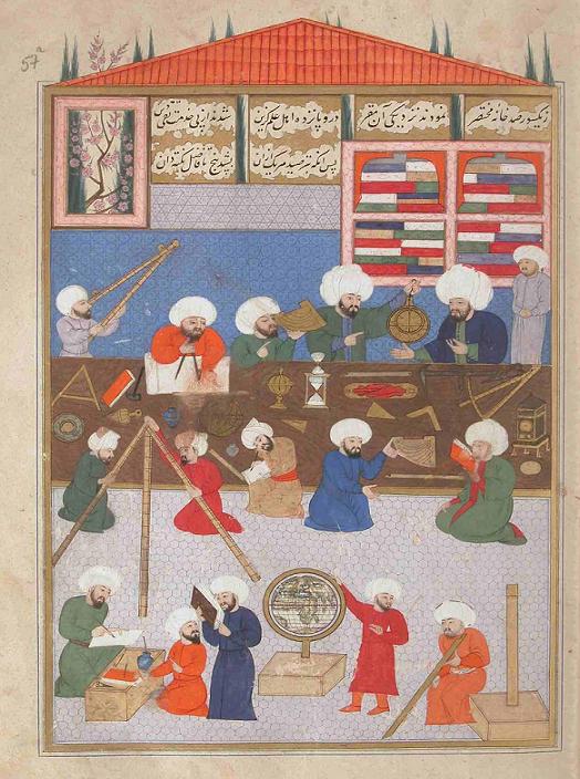
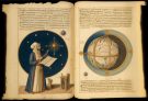
Figure 1: The overview of the astronomical instruments and staff of the Istanbul Observatory with Taqi Al-Din Rasid at work. Source: Shahinshahnāme Istanbul University Library, F 1404, fol. 57a.
The great changes in the scientific and educational life of the Ottomans were achieved over an extensive period of time. Consequently, it is difficult to connect the radical changes in Ottoman history to specific events or to start from a certain date. In general, “old and new” existed side by side. To substantiate such a claim, focus will be laid in this section on the formation and development of the classical Ottoman scientific tradition that was based on the Islamic classical scientific tradition, including the heritage of the Seljuks and other Muslim and Turkish states [1].
The Ottoman Empire was established as a small principality at the turn of the 14th century and gradually expanded into the Byzantine Empire and other Muslim and non-Muslim states. Its authority reached its highest point in the 16th century, and it became the most powerful state of the world. The Empire extended from Central Europe to the Indian Ocean and lasted for many centuries by keeping the balance of power with modern Europe [2].
Scientific activities in the Ottoman state emerged and developed in Anatolian cities from the scientific legacy and institutions of the pre-Ottoman Seljuk period and benefited from the activities of scholars who came from Egypt, Syria, Iran, and Turkestan—that is, from the substantial scientific and cultural centres of the time. Alongside the old centres of Islamic civilization, new centres, such as Bursa, Edirne, Istanbul, Amasya, Skopje, and Sarajevo flourished during to Ottoman period. The developments of this period form the heritage that constitutes the cultural identity and scientific legacy of present-day Turkey, as well as an important part of the intellectual history of several Middle Eastern, North African, and Balkan countries. The Ottomans also benefited greatly from their non-Muslim subjects and European neighbours, and provided very favourable working conditions for scientists from many different fields, including medicine, astronomy, and mathematics, by inviting them to conduct their studies at the important centres of science and culture in the Islamic world [3]. Engaging the services of scientists and artists from either the west or the east as needed, without regard to religion or nationality, was an established and advantageous practice in the Ottoman Empire [4].
Figure 2: The figure of the Sextant (mushabbaha bi’l-monātiq), an important astronomical instrument of Tāqī al-Din. Source: Ālāt al-rasadiya li-zīj al-shāhinshāhiyya, Library of the Topkapi Palace Museum, Hazine 452, fol. 14b.
During the classical period, Ottoman scientists and scholars showed remarkable success in developing science and were able to produce many works in various branches. This paper provides an overview, with examples, of the formation and development of Ottoman science and scientific activities in the fields of geography and astronomy.
From as far back as the time of the Prophet, we know that Muslims had needed astronomy for the determination of times, an important factor in religious duties, and geography to find the direction of the Ka’ba. The precise calculation of the prayer times, as well as of the beginning and the end of the daily fast in the month of Ramadan, fell naturally within the domain of the astronomer. It is true that for the times of regular prayers, for example, Muslims were given approximate directions and were allowed some latitude; simple rules concerning these matters could be found in the Traditions. From the very beginning of Islam, Muslim scholars had to work on these two subjects under very strict rules. Due to closeness of the fields, most of the Muslim scholars had a deep knowledge of both sciences and they produced a considerable number of books.
Astronomical studies in the Islamic civilization started in the very early days. Observations of the sun and the moon and the calculation of the prayer times required precision. The observatory was one of the most highly developed institutions of science and learning in Islam and one of the high-water marks of the Muslim civilization. There is no doubt that the observatory, as a specialized scientific institution, owes a great deal to Islam. It may very reasonably be claimed that it was in Islam that the observatory, as a specialized institution with an official and legal status and with a fixed location where observation and other work on stellar bodies was systematically carried out through the cooperation of several scientists, first came into existence.
Already early in the 9th century, the Caliph Al-Ma’mun initiated the tradition of founding observatories in Islam, by founding two major but very short-lived observatories, the Shammasiya in Baghdad and Qasiyun in Damascus. There are eight other examples of the building of full-fledged and elaborate official state observatories in the Islamic realm up to the 17th century.
The Maragha Observatory, founded in 1259 under the patronage of Hulagu, was one of the most elaborate institutions of its kind and the scene of important work. Prince Ulugh Bey built another gigantic observatory in Samarqand in 1420, and finally the Tophane Observatory in Istanbul was founded by Murad III in 1577.
2.1. Istanbul Observatory
In the Ottoman civilization, scientific institutions, in the field of astronomy, included the chief astronomer’s office (munajjimbashi), the muvaqqithānes and the Istanbul Observatory. Though one can find original and translated works in the fields of astronomy and astrology from the early period, the first calendrical works only began during the time of Sultan Murad II (1421-1451). These calendars were prepared as palace almanacs and we have no idea about the authors [5]. They continued the classical Islamic astronomical tradition in this field, and combined the traditions of both the Samarkand and Maragha astronomy schools of astronomy in their works. Ulug Bey’s Zīj, which was prepared in the Samarkand observatory, became a very significant manual for Ottoman astronomers and astrologers [6].
The Ottomans had well organized astronomical institutions such as the post of Chief-astronomer (munajjimbashilik) and time keeping houses (muwaqqithānas). In the Ottoman palace administration, the person in charge of directing the astronomers was called munajjimbashi, that is Chief Astronomer. The position of Chief Astronomer was established sometime between the late 15th and early 16th centuries. The Chief Astronomer’s most important duty was the preparation of annual calendars. They were responsible for determining the beginning of fasting times (imsāqiya) before the month of Ramadan and preparing horoscopes (zāyija) and astronomical tables (zījs) for the palace people and prominent officials.
The timekeeper’s offices (muvaqqithānes) were public buildings located in the courtyards of mosques or masjids in almost every town. They were widely built by the Ottomans especially after the conquest of Istanbul. They were administered by the foundation (waqf) of the complex (külliye) and the people who worked in the muvaqqithānes were named muvaqqit, meaning the person who kept the time, especially for the times of prayer.
In addition to other science related institutions, the observatory founded in Istanbul was administered by the chief astronomer Taqī al-Dīn al-Rasid (d. 1585). The first Ottoman observatory was also the last big observatory of the Islamic Civilization. With the support of Sultan Murad III, he started the construction of the Istanbul observatory. As well as using the existing instruments of observation, Taqī al-Dīn invented new ones in order to determine the equinoxes. He also developed and used gravity and spring driven mechanical clocks and invented a six-cylinder pump (engine) for raising water in a continuous manner [7]. In addition, he wrote more than thirty books in mathematics, astronomy, mechanics, and medicine.
Taqi al-Din, who was born in Damascus in 1526, worked for a time as a qadīi and a teacher after completing his education in Damascus and Egypt. During his time in Egypt and Damascus, he produced some important works in the fields of astronomy and mathematics. In 1570, he came to Istanbul from Cairo, and one year later (1571-2) was appointed Chief Astronomer (Munajjimbashi) on the death of the Chief Astronomer Mustafa b. Ali al-Muwaqqit. Taqi al-Din maintained close relationships with many important members of the ulemā (scholars) and statesmen, chief among whom was Hoca Sādeddin, and was presented to Sultan Murad by the Grand Vizier Sokullu Mehmed Pasha [8].
Taqi al-Din informed Sultan Murad, who had an interest in astronomy and astrology, that the Ulug Beg’s Astronomical Tables contained certain observational errors, resulting in errors in the calculations based on those tables. Taqi al-Din indicated that these errors could be corrected if new observations were made and proposed that an observatory be built in Istanbul for that purpose. Sultan Murad was very pleased to be the patron of the first observatory in Istanbul and asked that construction begin immediately. He also provided all the financial assistance required for the project. In the meantime, Taqi al-Din pursued his studies at the Galata Tower, and continued them in 1577, at the partially completed new observatory called Dār al-Rasad al-Jadīd (the New Observatory).
The observatory, consisting of two separate buildings, one large and one small, was constructed at a location in the higher part of Tophane in Istanbul. Taqi al-Din had the instruments used in the old Islamic observatories reproduced with great care. In addition, he invented some new instruments, which were used for observational purposes for the first time. The observatory had a staff of sixteen people: eight “observers” (rāsid), four clerks, and four assistants [9].
The observatory was designed to provide for the needs of the astronomers and included a library largely consisting of books on astronomy and mathematics. This institution was conceived as one of the largest observatories in the Islamic world and was completed in 1579. It was comparable to Tycho Brahe’s (1546-1601) Uranienborg observatory built in 1576 [10]. In addition, there is a striking similarity between the instruments of Tycho Brahe and those of Taqi al-Din but those of Taqi al-Din were of superior quality [11]. When compared with those of his contemporary Danish astronomer, Taqi al-Din’s observations are more precise.
In Taqi al-Din’s astronomical tables, called the Sidratu Muntaha’l-Afkār fī Malakut al-Falak al-Davvār (Lotus of Culmination of Thoughts in the Kingdom of Rotating Spheres), Taqi al-Din states that he started astronomical activities in Istanbul with 15 assistants in 1573 [12]. The observatory continued to function until 22 January 1580, the date of its destruction. Religious arguments were put forth to justify this action, but it was really rooted in certain internal political struggles [13].
2.2. New observational instruments of Taqi al-Din
Taqi al-Din invented new observational instruments that were added to those already in use for observation in the Islamic world. Among the instruments invented by Taqi al-Din in the observatory were the following:
The Sextant (mushabbaha bi-‘l manātiq): used to measure the distances between the stars. Taqi al-Din’s mushabbaha bi’l manātiq and Tycho Brahe’s sextant should be considered among the great achievements of the 16th century astronomy. A mushabbaha bi-l manātiq is composed of three rulers. Two of them are attached as the rulers of the triquetrum. An arc is attached to the end of one of the rulers. Taqi al-Din made this instrument to observe the radius of Venus that was mentioned in the Xth book of the Almagest[14].
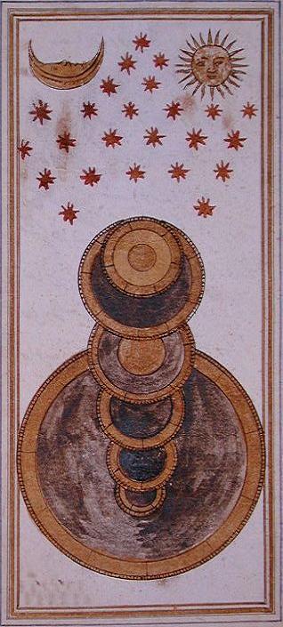
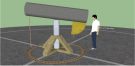
The instrument with cords (Dhāt al-awtar): designates the spring and autumn equinoxes. Some astronomers set up a ring, which was not divided, parallel to the equator to designate this. The instrument was composed of a base in the form of a rectangle and four columns. The two columns were set on this base so that a string was stretched between them. One of them was equal to the cosine of the latitude of the country and the other to the sine. A hole was made on each of these parts according to this proportion. A rope was hung from these holes with a plumb [15].
Figure 3: The figure of Dhāt al-awtār. Source: Ālāt al-rasadiya li-zīj al-shāhinshāhiyya, Library of the Topkapi Palace Museum, Hazine 452, fol. 13b.
The astronomical clock: Taqi al-Din used a mechanical clock, which he made himself for his observations, and a wooden wall dial, which he set up in the observatory. He wrote in The Astronomical Instruments for the Emperor’s Table: “The ninth instrument is an astronomical clock. The following statement is recorded from Ptolemy: ‘I would have been able to establish a great regularity in method if I was able to measure the time precisely.’ Now Taqi al-Din planned, with the help of God, the astronomical clock by the command of the Sultan, God perpetuates his ruling days. Thus, he was able to do what Ptolemy had failed to do.” Taqi al-Din says in Sidrat al-muntahā: “we built a mechanical clock with a dial showing the hours, minutes and seconds and we divided every minute into five seconds.” This is a more precise clock than clocks used previously and is, as a result, considered to be one of the most important 16th century developments in applied astronomy [16].
When we compare the instruments which Taqi al-Din used in his observatory with those used by Tycho Brahe, they are mostly similar, but some of Taqi al-Din’s are larger and more precise. Both, for example, used a mural quadrant (Libna) for the observations of the declinations of the sun and the stars. It is said that Taqi al-Din preferred the mural quadrant to the Fakhri sextant (Suds-i Fakhrī) and two rings used by previous astronomers. Taqi al-Din’s quadrant was composed of two brass quadrants with a radius of six meters; it was placed on a wall and erected on the meridian. Tycho Brahe’s similar instrument was only two meters in diameter [17].
In his work, Taqi al-Din integrated two traditions of astronomy, those of Damascus and Samarkand. His first task at the observatory was to correct the Zīj book (Astronomical Table) of Ulugh Beg. He also undertook various observations of eclipses of the sun and the moon. The comet that was present in the skies of Istanbul for one month during September 1578 was observed day and night and the results of the observations were presented to the sultan. As a result of the new methods he developed and the equipment he invented, Taqi al-Din was able to approach his observations in an innovative way and produce novel solutions to astronomical problems. He also substituted the use of a decimally based system for a sexagesimal one and prepared trigonometric tables based on decimal fractions. He determined the ecliptic degree as 23° 28′ 40″, which is very close to the current value of 23° 27′. He used a new method in calculating solar parameters. He determined that the magnitude of the annual movement of the sun’s apogee was 63 seconds. Considering that the value known today is 61 seconds, the method he used appears to have been more precise than that of Copernicus (24 seconds) and Tycho Brahe (45 seconds). Taqi al-Din also wrote the first Ottoman book on automatic machines, titled el-Turuq al-Saniyya fi’l-ālāt al-rūhāniyya[18].
The observatory was witness to a great deal of activity within a short period of time. Observations undertaken there were collected in the above mentioned treatise Sidratu Muntahā’l-Afkār fī Malakūt al-Falak al-Davvār.
2.3. Mustafa bin Ali Al-Muwaqqit
Mustafa b. Ali al-Muwaqqit al-Salīmī was another essential Ottoman polymath scholar [19]. He was well-known in the second half of the 16th century as an astronomer, mathematician, geographer, clock-maker (sa’atji) and muwaqqit (timekeeper). He made valuable contributions in the fields of astronomy and geography, producing many books of which those on making and using astronomical instruments are particularly important. These books were used as textbooks in madrasas, and some of them were copied until the middle of the 19th century.
Figure 4: The figure of astronomical clock. Source: Ālāt al-rasadiya li-zīj al-shāhinshāhiyya (T), Library of the Topkapi Palace Museum, Hazine 452, fol. 16a.
He was initially timekeeper at the Yavuz Selim Mosque in Istanbul and later became the Chief Astronomer (munajjimbashi) for ten years. He took astronomy courses and became muwaqqit at the Sultan Selim Mosque Muwaqqithana. He wrote most of his works while holding this post. He invented a new instrument for astronomical observation called the “rub-i āfākī” (horizontal quadrant).
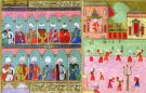
There are 24 works which are definitely known to have been written by him; three in Arabic, the rest is in Turkish. By writing in the Turkish language about astronomical matters, he was aiming to make astronomical works accessible in this language who was becoming the scientific language of the Ottoman Empire. He also produced new and original solutions to astronomical problems. Therefore, his ideas became widely diffused among astronomers, muwaqqits and other educated people. In particular, his book explaining astronomical instruments was very popular among those interested in astronomy. In addition to astronomy, he also wrote three treatises of geography: Hallu Dā’irati Mu’addil al-Nahār, I’lam al-‘Ibād fī A’lām al-Bilād I’lām al-‘Ibād fī A’lām al-Bilād and Kifayāt al-Wakt li Ma’rifat al-Dā’ir wa Fazlihī wa al-Samt[20].
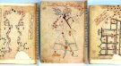
Figure 5: Sample extracts form Mustafa b. Ali al-Muwaqqit’s I‘lam al-‘Ibād fī A‘lām al-Bilād. Source: Kandilli Rasathanesi El Yazmalari 1: Türkçe Yazmalar, proje sorumlusu: Günay Kut, İstanbul: Boǧaziçi Üniversitesi Yayinevi, 2007, p. 538.
As in the field of astronomy, the Ottomans continued the classical tradition in the field of geography. The Ottomans needed geographical knowledge in order to determine the borders of their continuously expanding territory and to establish control over military and commercial activities. They made use of both the geographical works of previous Muslim geographers and works of European origin. By adding their own observations, Ottoman geographers also produced original material [21]. The Samarkand school of geography and astronomy provided the primary sources for the Ottoman’s knowledge of geography, map-making and related fields. From the 16th century onwards, Pīrī Reis, Matrakci Nasuh, Saydī Ali Celebi and other scholars produced noteworthy geographical works.
3.1. Pīrī Reīs
The most prominent Ottoman geographer is Muhiddin Pīrī Reīs (d. 962 A.H./1554 C.E.) who also produced original works in the fields of marine geography and navigation at the court of Selim I and Suleyman the Magnificent. He was interested in the science of cartography and completed a map of the world in 1513 C.E. This map is part of the large scale world map prepared in two parts on a gazelle hide, of which only the western part is preserved. It was drawn based on both his rich and detailed drafts and European maps, including Columbus’ map of America. This was the first Ottoman map which included preliminary information about the New World depicts southwestern Europe, northwestern Africa, southeastern and Central America. The map has the shape of a “portland” type of map which does not contain latitudinal and longitudinal lines, but includes coastlines and islands and serves to familiarize one with the various regions of the world.
Pīrī Reīs also drew a second world map in 1528 C.E. which he presented to Süleyman the Magnificent. Only the portion depicting the western hemisphere survives. It is in colour and has ornamental figures on the margins with explanatory notes. The extant portion shows the northern part of the Atlantic Ocean and the newly discovered regions of North and Central America. It shows four wind roses and the Tropic of Cancer, which was not shown in his first map of the world, appears on this map. The scales used in the second map are larger than the first. The drawing of the coastlines shows a great improvement in technique and also bears a close resemblance to the modern conception of these areas. The stony and rocky sections are given special care.
Pīrī Reis also wrote a book on marine geography entitled Kitāb-i Bahriye (Book of the Sea, 1521). In this work, he presents drawings and maps of the cities on the Mediterranean and Aegean coasts, and gives extensive information about navigation and nautical astronomy. The book contains 209 chapters with 215 maps, charts and pictures to give exact account of the coasts and islands of the Mediterranean and the Black Sea, along with a description of the seas. Basically the book is a kind of guide to navigation and is based on his personal observations. He gathered together all previous information on the subject but added to it other practical knowledge necessary for sailors on the most important coastal routes, and drew large maps for every chapter. In this way, the book became not only a simple guide book, but also the greatest Ottoman contemporary portolano with the most advanced cartography techniques.
3.2. Seydī Ali Reis
Another outstanding personality was the Ottoman admiral, geographer, astronomer and poet Seydī ‘Ali Reis (also as known Kātibī or Kātib-i Rûmī) (d. 1562), who was an expert on marine geography [22]. He wrote books on geography, mathematics and astronomy which show his scientific and navigational experience and knowledge. His works, written in Turkish, are chiefly translations from Persian or Arabic and deal with mathematics, astronomy and navigation in the Indian Ocean. Some of his works have been translated into many languages. In addition to geography, he also wrote books on mathematics and astronomy. He wrote a very valuable work in Turkish, entitled Kitāb al-Muhīt fī ‘ilm al-aflāk wa al-Abhur well-known as al-Muhīt (The Ocean) containing the astronomical and geographical information required for long sea voyages as well as his own observations about the Indian Ocean. After his travelogue, this is Saydī ‘Ali’s most famous work, and is based on Arabic works dealing with navigation in the Indian Ocean. The al-Muhīt consists of 10 sections and of Portuguese voyages of discovery, including Magellan’s circumnavigation of the globe [23]. Saydī ‘Ali’s account enhances the reputation of the Ottoman sultan among his co-religionists everywhere he travelled, and demonstrates the universality of the Turkish element and the effectiveness of Ottoman Turkish soldiers, who were in demand at every court.
In addition to this geographical work, he also wrote treatises on astronomy. The first of which is Mir’āt-i kāināt (Mirror of the Universe), a treatise on astronomical measurements and instruments, chiefly applicable to the art of navigation by celestial observation. This has been translated into many languages. His second book on astronomy is Hulāsat al-hay’a (Essence of Astronomy), a treatise on geometry and mathematics containing a translation of ‘Ali Qushji’s al-Fathiyya fī al-Hay’a, enriched with excerpts from Chaghmīnī and Kadizade-i Rumī. His other books on astronomy are: Risala-i Dhāt al-Qursī a treatise about astronomy and some astronomical instruments; Risala-i mir’at-i kā’inat min alāt-i irtifa’ which is called the Mirror of the Universe according to instruments for measuring altitude. His other works are: Risala-yi hay’at (Treatise on Astronomy); Sayahat-nāma-yi asturlab rub’ mujayyab ‘amal bi’l-jayb muqantarāt da’ira al-mu’addal dhāt al-kursī (Book of travel on the astrolabe, sine Quadrant, Equatorial Circle, and the Instrument with a Throne); Risala-i Da’irat al-Mu’addil [24];Risala-i Asturlab and Risala-i Rub’i Mujayyab.
Figure 6: Pīrī Reis’ first map presented to Sultan Selim I. Source: Topkapi Palace Museum Library, H. 1824.
Another significant Ottoman polymath scholar was Matrakci Nasûh b. Karagöz al-Bosnawī al-Silahī [25]. He was renowned in the 16th century as a mathematician, historian, geographer, cartographer, topographer, musketeer, and was an outstanding soldier, calligrapher and engineer. He made contributions in the fields of geography, mathematics, history, military art and calligraphy and produced important books. He also invented a military lawn game called “Matrak”. Matrakçi Nasuh was an important figure in the field of descriptive geography. His first important book Bayān-i Manāzil-i Safar Iraqayn (Explanation of encamping places of two expeditions of Iraq) was in Turkish [26]. His miniatures showing the roads connecting Istanbul, Tabriz and Baghdad are like maps. His history of the 1534-36 campaign to Iran and Iraq [27] includes a double folio depicting Istanbul with all the contemporary structures of the city shown in remarkable detail [28]. The Golden Horn runs vertically in the centre, separating the Galata section with its famous tower (on the left) from the city proper (on the right), which includes such major structures as the Topkapi Palace, Hagia Sophia, At Meydani (Hippodrome), Grand Bazaar, Old Palace, and the complex (kulliya) of Mehmed II. A major document for the study of Istanbul in the 1530’s, the illustration is an example of the topographic genre of painting initiated by Nasuh that continued for centuries.
Figure 7: The map of Istanbul. Source: Matrakci Nasuh, Bayān-i Manāzil-i Safar Iraqayn. Source: Istanbul university library. T 5964.
Matrakçi’s land maps are considered equal with Pīrī Reis’ portland maritime maps to be found in his Kitāb-i Bahriye[29]. Two other works of Matrakçi containing miniatures are important from a geographical perspective. In one called Ta’rikh-i Fath-i Shiklos wa Estergon wa Istolnibelgrad, Matrakçi drew the inns between Istanbul and Budapest as well as the cities of Nice, Toulon and Marseilles during Barbaros’ visits and the Ottoman fleet with which he came [30].
As a member of the administration, Nasuh accompanied Suleyman the Magnificent on various campaigns and carefully recorded the events and illustrated the cities and ports conquered by the Ottomans. He participated in the Mohaç campaign (1526) and the two Baghdad expeditions of Suleyman. He painted the picture of every city where the army was billeted or passed by [31].
Figure 8: The world map from Tarih-i Hind-i Garbī. Source: Beyazit Library, MS 4696.
Another work of the 16th century in the field of geography, which contains information about the geographical discoveries and the New World (America), is the book entitled Tārih-i Hind-i Garbī (History of the West Indies) (probably written by Muhammad b. Amir al-Suûdī al-Niksarī (d. 1591) in the 16th century) [32]. This work, based on Spanish and Italian geographical sources, was presented to Sultan Murād III in 1573. It is important in showing that the Ottomans knew about the geographical discoveries of the West. The work has three parts; but the real weight, consisting of two-thirds of the book, is in the third section where Columbus’ discovery of America and the European conquests over the period of sixty years between 1492 and 1552 are related. Tarih-i Hind-i Garbī tells the amazing stories of the explorations and conquests of Columbus, Cortes, Pizarro, and others, and it also endeavours to incorporate the new geographic information into the body of Islamic knowledge. It presents a major effort by an Ottoman Muslim scholar, almost unique in the 16th century; firstly, to transmit through translation information from one culture (European Christendom) to another (Ottoman Islam), and secondly, to correct and expand Islamic geography and cartography [33].
In the Topkapi Palace Museum Library (Hazine 644), Istanbul, there is an Atlas entitled “Ali Macar Reis Atlas”. The atlas consists of six portolan charts and one mappamundi, all on double pages, i.e., there are fourteen pages [34]. They are drawn on parchment leaves and bound in leather, forming an appealing small volume [35]. As a work of art, this atlas certainly ranks among the most successful. The artist-cartographer who drew these charts must have been professionally connected to those who drew other similar maps in Christian Europe; and the artistic perfection of this atlas strongly argues against it being the isolated work of a captain who would only have been imitating such models; the author must have been a craftsman with great experience of this type of work.
Figure 9: World Map in Ali Macar Reis’ Atlas. Source: Topkapi Palace Museum Library, H. 644 (1577/3594).
Cartography seems to have been organized as a profession in the Ottoman Empire; for example, in the 17th century, fifteen individuals were occupied with the art of surveying, in eight locations in Istanbul and nearby areas.
Ottoman geographers were able to obtain information about both West and East at a time when there were no maps of the East available in Europe. This indicates that the Ottomans were more advanced in this area than had previously been thought.
Ottoman contributions to geography including cartography are very significant, vast, in content and have a definite place in the history of geography. It is also true that while the Arabs mostly influenced the Turks they did not follow them slavishly. Ottoman geographers especially cartographers made some very significant contributions and they may be said to have formed a bridge between medieval Islamic and modern cartography [36].
Ottoman contributions to Science and Technology during a six hundred year rule over a huge domain are beyond measure. The above is merely a brief outline of some of the Ottoman scientific activities and related institutions that brought about the revival of culture, science, and learning in civilizations throughout the world. Many excellent works exist that can guide future researchers interested in this subject. Opportunities for further study abound, as the examples presented in this paper could certainly be extended to cover a larger percentage of the vast contributions the Ottomans made over six hundred years. The classical scientific tradition that produced its finest works in the most magnificent period of the Empire was set forth in the scientific and educational institutions that have been briefly mentioned, in the scholarly circles established, and developed around these institutions. Still, the Ottoman classical tradition was preserved during this second phase of Ottoman science, when many more translations and transfers were made from European languages, and survived with some of its basic elements until the second half of the 19th century.
End Notes
[1] Ekmeleddin Ihsanoglu, “Ottoman Educational and Scholarly-Scientific Institutions,” in vol. 2 of History of the Ottoman State, Society and Civilisation, ed. Ekmeleddin Ihsanoglu (İstanbul: IRCICA, 2002), 361-512.
[2] Halil Inalcik, The Ottoman Empire: Conquest, Organization and Economy, (London: Variorum, 1978).
[3] Salim Aydüz, Tophâne-i Âmire ve Top Döküm Teknolojisi, (Ankara: Türk Tarih Kurumu, 2006).
[8] J. H. Mordtmann, “Das Observatorium des Taqi ed-din zu Pera,” Der Islam vol. 12 (1913): 93; Ramazan Şeşen, “Meşhur Osmanli Astronomu Takiyüddin El-Râsid’in Soyu Üzerine,” Erdem 4, issue 10 (1988): 165-171; Cevat İzgi, Osmanli Medreselerinde İlim, vol. 1 (İstanbul: İz Yayincilik, 1997): 301-302, 327, 192; İzgi, vol. 2: 128-132; Salim Aydüz, “Takiyüddin Râsid,” Yaşamlari ve Yapitlariyla Osmanlilar Ansiklopedisi, vol. 1 (İstanbul: Yapi Kredi Yayinlari, 1999): 603-605. See for Taqi Al-Din’s list of manuscripts and related works: Aydüz, Salim, Taqī al-Dīn Ibn Ma’rūf: A Bio-Bibliographical Essay. Published on www.MuslimHeritage.com (26 June, 2008).
[9] Ahmet Süheyl Ünver, İstanbul Rasathânesi (Ankara: Türk Tarih Kurumu, 1986): 43-47.
[10] J. L. E. Dreyer, Tycho Brahe: A Picture of Scientific Life and Work in the Sixteenth Century (New York/London: Dover Publications/Constable, 1963).
[11] Sevim Tekeli, “Nasiruddin, Takiyüddin ve Tycho Brahe’nin Rasat Aletlerinin Mukayesesi,” Ankara Üniversitesi, Dil ve Tarih Coǧrafya Fakültesi Dergisi 16, no. 3-4 (1958): 224-259.
[12] Topkapi Palace Museum Library, MS Hazine no. 465/1. In addition, look: Sevim Tekeli, “Trigonometry in Two Sixteenth Century Works; The De Revolutionibus Orbium Coelestium and the Sidra al-Muntaha,” History of Oriental Astronomy (Cambridge: Cambridge University Press, 1987), 209-214.
[13] Sevim Tekeli, “İstanbul Rasathânesinin Araçlari,” Araştirma 11 (1979): 29-44; S. Tekeli, “Takiyüddin’de Kiriş 2° ve Sin 1° nin Hesabi,” Araştirma 3 (1965): 123-127; S. Tekeli, “Takiyüddin’in Delos Problemi ile ilgili Çalişmalari,” Araştirma 6 (1968): 1-9; S. Tekeli, “Takiyüddin’in Sidret ül-müntehasinda Aletler Bahsi,” Belleten 30, no. 98 (1961): 213-227.
[14] Sevim Tekeli, “Astronomical Instruments for the Zîj of Emperor,” Arastirma 1 (1963): 86-97.
[16] Aydin Sayili, The Observatory in Islam (Ankara: Türk Tarih Kurumu, 1991), 289–305; Aydin Sayili, “Alauddin Mansur’un İstanbul Rasathânesi Hakkindaki Şiirleri,” Belleten 20, no. 79 (1956): 414, 466.
[17] Sevim Tekeli, “Meçhul bir yazarin İstanbul Rasathesi Aletlerinin Tasvirini veren: Alat-i Rasadiye li Zic-i Şehinşahiye Adli Eseri,” Araştirma 1 (1963): 12–71.
[19] He was also known as “Müneccimbaşi Mustafa Çelebi” and “Koca Saatçi”.
[20] Yavuz Unat, “Mustafa Ibn Ali el-Muvakkît ve İ’lâm el-‘İbâd fî A’lâm el-Bilâd (Şehirler Aleminde Mesafelerin Bildirimi) Adli Risalesi”, EJOS, VII, (2004), No. 10, pp. 1-47.
[21]History of geographical literature during the Ottoman period, Ekmeleddin İhsanoǧlu and others, (İstanbul: IRCICA, 2000).
[22] Abbas ‘al-`Azzawi. Tarikh `ilm ‘al-falak fi ‘al-`Iraq wa-`alaqatihi bi-‘al-‘aqtar ‘al-‘Islamiyah wa-‘al-`Arabiyah fi ‘al-`uhud ‘al-taliyah li-‘ayyam ‘al-`Abbasiyin: min sanat 656 H.=1258 M. ‘ila sanat 1335 H.=1917 M. [Baghdad]: Matba`at ‘al-Majma` ‘al-`Ilmi ‘al-`Iraqi, 1958, 254-257; Adivar, A. Adnan. Osmanli Turklerinde Ilim. Ankara: Remzi Kitabevi, 1970, pp. 85-89; Ak, Mahmut. “Saydī ‘Ali Reis”. Yasamlari ve Yapitlariyla Osmanlilar Ansiklopedisi. Istanbul: Yapi Kredi Kultur Yayinlari, 1999, II, pp. 525-527; Bursali Mehmed Tahir. Osmanli Muellifleri. Istanbul: Matbaa-i Amire, 1923. III, 270-272; Diez, H. Friedrich. Denkwürdigkeiten von Asien. Berlin 1815, II, 133-267; Hajji Khalifa. Kashf al-Zunun ‘an isama al-kutub wa’l-funun. Ankara: Milli Egitim Bakanligi, 1941, I, 807; History of Astronomical Literature during the Ottoman Period. By. Ekmeleddin Ihsanoglu and others. Istanbul: Research Center for Islamic History, Art and culture, 1997. I, 140-145; History of Geographical Literature during the Ottoman Period. By. Ekmeleddin Ihsanoglu and others. Istanbul: Research Center for Islamic History, Art and culture, 2000. I, 35-38; Izgi, Cevat. Osmanli Medreselerinde Ilim. Istanbul: Iz Yayincilik, 1997, I, 344, 388, 394, 449, 450; II, 256, 257; King, David A. A survey of the scientific manuscripts in the Egyptian National Library. Winona Lake [Ind.]: Eisenbrauns, 1986. 171; Krachkovskiy, Ignatiy Yulianovich. Arabskaya Geograficheskaya Literatura. Izbrannyye sochineiniya. 4. M.-Lg., 1957. pp. 569-578; Mehmed Sureyya. Sijill-i Osmani. Istanbul: Matbaa-i Amire, 1308. II, 498-499; Ors, Hayrullah and Mustafa Nihad Ozon. Hindistan’dan Istanbul’a. Ankara 1935; Rosenfeld, Boris A. and Ekmeleddin Ihsanoglu, Mathematicians, astronomers and other scholars of Islamic civilisation and their Works (7th -19th c.). Istanbul: Research Center for Islamic History, Art and culture, 2003, pp. 325-326, No. 977; Soucek, Svat. “Sidi ‘Ali Reis. (Saydī ‘Ali Reis)”, Encyclopaedia of Islam. CD-ROM Edition 1999, Koninklijke Brill NV, Leiden, The Netherlands; C.A. Storey, Persian Literature: A Bio-bibliographical survey. Leiden: Published by the Royal Asiatic Society of Great Britain and Ireland, Sole agents: E. J. Brill, 1977, II, 76-77; Süssheim, Karl. “‘Ali (Sidi ‘Ali) b. Husain”, Encyclopeida of Islam, Ist ed., 1913, 301-302; Suter, Heinrich. “Die Mathematiker und Astronomen der Araber und ihre Werke”, Abhandlungen zur Geschichte der mathematischen Wissenschaften mit Einschluss ihrer Anwendungen; 10. Hft. Leipzig: B. G. Teubner, 1900. A, 188-190; Turan, Serefeddin. “Saydī ‘Ali Reis”, Islam Ansiklopedisi. Ankara: Milli Egitim Bakanligi, 1966, X, 528-531; Uzuncarsili, Ismail Hakki. Osmanli Tarihi. Ankara: Turk Tarih Kurumu, 1998, II, 398-400, 606.
[23] M. Bittner, “Die topographischen Capital des indischen Seespiegels, Mohit”, Festschrift 1897; Comprehensive (Book) on the Science of Heavens and Seas (al-Muhīt fi ‘ilm al-aflak wa’l-abhur), Naples, Vienna 1277; Gabriel, Ferrand. L’amiral Sidi ‘Ali et le Muhit. Introduction à l’astronomie nautique Arabe. Paris 1936; Mir’at al-mamalik. The travels and adventures of the Turkish Admiral Sidi ‘Ali Reis in India, Afghanistan, Central Asia, and Persia, during the years 1553-1556. Trans. by. A. Vambéry. London: Luzac, 1899; Mir’atu’l-Memalik: Inceleme, metin, indeks, Saydī ‘Ali Reis. Published by Mehmet Kiremit. Ankara: Turk Dil Kurumu, 1999; Saydī ‘Ali Rais. Mir’atul mamolik (Mamlakatlar kuzgusi). By. S. Zumnunab. Tashkent, 1963; Saydī ‘Ali Reis, Mir’at al-Mamalik. By Ahmad Jawdat Pasha. Istanbul: Ikdam Matbaasi, 1313 (1895); Sidi Rais. Die topographische Capitel des indischen Seespiegel Mohit. Übers. Von M. Bittner, mit einer Einleitung von W. Tomaschek. Wien, 1897.
[24] William Brice, Colin Imber and Richard Lorch, The Da’ire-yi Mu’addel of Saydī ‘Ali Re’is, Seminar on Early Islamic Science, Monograph No. 1. Manchester: The University of Manchester, 1976.
[25] Goodrich, Thomas D., “Old Maps in the Library of Topkapi Palace in Istanbul”, Imago Mundi, vol. 45. (1993), pp. 120-133; Grabar, Oleg, “An Exhibition of High Ottoman Art”. Muqarnas, vol. 6 (1989), pp. 1-11; History of Geography Literature during the Ottoman Period. Edited by Ekmeleddin İhsanoǧlu et al., Istanbul: IRCICA, 2000, I, 42-45; History of Mathematical Literature during the Ottoman Period. Edited by Ekmeleddin İhsanoǧlu et al., Istanbul: IRCICA, 1999, I, 68-73; History of Military Art and Science Literature During the Ottoman Period. Edited by. Ekmeleddin İhsanoǧlu et al., Istanbul: IRCICA, 2004, I, 10-11; İhsanoǧlu, Ekmeleddin, “The Ottoman Scientific-Scholarly Literature”. In History of the Ottoman State, Society and Civilization, II, Istanbul: IRCICA, 2002, pp. 543, 567-568; Johnston, Norman J., “The Urban World of the Matraki Manuscript”, Journal of Near Eastern Studies, vol. 30, No. 3. (July 1971), pp. 159-176; Kara, I., “Nasuh Matrakçi”, Türk Dili ve Edebiyati Ansiklopedisi, Devirler, isimler, terimler. İstanbul: Dergah Yayinlari, 1977, VI, pp. 527-8; Mahir, Banu-İhsan Fazlioǧlu, “Nasuh (Matrakçi)”, . Istanbul: YKB, 1999, II, 350-351; Matrakçi Nasuh Bey b. Abdulah (Karagöz) al-Silahi, Beyân-i Menâzil-i Sefer-i Irakeyn-i sultan süleyman han. Published by H. G. Yurdaydin. Ankara, 1976; Selen, H. S., “16inci asirda yapilmiş Anadolu atlasi: Nasuh Silahi’nin Menâzil’i”, İkinci türk tarih kongresi, Istanbul 20-25 Eylül 1937 kongrenin çalişmalari, kongreye sunulan tebliǧler. Istanbul, 1943, pp. 813-817; Soucek, S., “Islamic Charting in the Mediterranean”, in The History of Cartography: Cartography in the Traditional Islamic and South Asian Societies, edited by J. B. Harley and David Woodward. Chicago: The University of Chicago, 1992, pp. 235-253; Taeschner, Franz, “The Itinerary of the First Persian Campaign of Sultan Süleyman, 1534-36, According to Nasuh al-Matraki”, Imago Mundi, vol. 13 (1956), pp. 53-55; Yurdaydin, H. G., “An Ottoman Historian of the XVIth Century: Nasuh al-Matrakî and his Beyân-i Menâzil-i Sefer-i ‘Irakeyn and its Importance for some Iraki Cities”, Turcica, vii (1975), pp. 179-87; Yurdaydin, H. G., “Matrakçi Nasuh’un Minyatürlü iki yeni eseri”. Atti II. Congree İnternational Acta Turca, Venezia, 1963. Venedik, 1965, pp. 283-286; Yurdaydin, H. G., “Matrakçi”, Encyclopaedia of Islam, Leiden: Brill, CD version, 2001; Yurdaydin, H. G., Matrakçi Nasuh. Ankara, 1963.
[26] Nasuh b. Abdullah Matrakçi Nasuh, Beyan-i menazil-i sefer-i Irakeyn-i Sultan Süleyman Han, ed. Hüseyin G. Yurdaydin (Ankara: Türk Tarih Kurumu, 1976).
[27] Franz Taeschner, “The Itinerary of the First Persian Campaign of Sultan Süleyman, 1534-36, According to Nasuh al-Matraki”, Imago Mundi, vol. 13 (1956), pp. 53-55.
[28] S. Soucek, “Islamic Charting in the Mediterranean”, in The History of Cartography: Cartography in the Traditional Islamic and South Asian Societies, edited by J. B. Harley and David Woodward. Chicago: The University of Chicago, 1992, pp. 235-253.
[29] Thomas D. Goodrich, “Old Maps in the Library of Topkapi Palace in Istanbul”, Imago Mundi, vol. 45. (1993), pp. 120-133.
[30] Norman J. Johnston, “The Urban World of the Matraki Manuscript”, Journal of Near Eastern Studies, vol. 30, No. 3. (July 1971), pp. 159-176.
[31] Turkish history institution (Turk Tarih Kurumu) published the city paintings he made during the expedition (edited and published by H. G. Yurdaydin, in 1976).
[32] This manuscript is stored at the Beyazit Library, MS 4696.
[33] This book published as facsimile by Cultural Ministry of Turkey: Muhammed b. Emir el-Hasan Sudi, Tarih-i Hind-i Garbi veya Hadis-i Nev: A History of the Discovery of America, İstanbul: Kültür ve Turizm Bakanliǧi, 1987. Thomas D. Goodrich, The Ottoman Turks and the New World: A Study of Tarih-i Hind-i Garbi and Sixteenth-Century Ottoman Americana, Near and Middle East monographs, new series, vol. 3, Wiesbaden: O. Harrassowitz, 1990, pp. 1-3.
[34] On the page 4b there is one note about the author. It is a short sentence in Arabic along the right hard margin of the page, in the area of the Atlantic along the western coast of Spain; the approximate translation: ‘The Humble Ali Macar wrote it with the aid of the Lord of Decision (i.e., God) in the month of Safar, year 975′, i.e., between August 7 and September 4, 1567. No other chart or atlas made by him is known. The first impression thus might be that an Ottoman seaman made this atlas on the basis of his maritime experience. And despite the date given of 1567, there is minor yet significant evidence that he drew this atlas before 1542; for on 6a, Scotland is separated from England by a channel which disappeared from Italian charts after that year.
[35] S. Soucek, “The ‘Ali Macar Reis Atlas’ and The Deniz Kitabi: Their Place in the Genre of Portolan Charts and Atlases”, Imago Mundi. A Review of Early Cartography, N. 25 (1971), pp. 17-27; Özdemir, Kemal. Ottoman Nautical Charts and the Atlas of Ali Macar Reis, A Marmara publication. Istanbul: Creative Yayincilik ve Tanitim, 1992.
[36]New Encyclopedia of Islam, vol. IV, p. 1082; N. Akmal Ayyubi, “Turkish Contributions to Islamic Geography”, Erdem, vol IX, 26 (Ankara 2002) pp. 483-489.
*Senior Researcher at the Foundation for Science, Technology and Civilisation (FSTC) and Visiting Scholar at the University of Manchester and Associate Professor at Fatih University, Istanbul. Email:ayduz@fstc.org.uk.
This website uses cookies to improve your experience. We'll assume you're ok with this, but you can opt-out if you wish. Cookie settingsACCEPT
Privacy & Cookies Policy
Privacy Overview
This website uses cookies to improve your experience while you navigate through the website. Out of these cookies, the cookies that are categorized as necessary are stored on your browser as they are as essential for the working of basic functionalities of the website. We also use third-party cookies that help us analyze and understand how you use this website. These cookies will be stored in your browser only with your consent. You also have the option to opt-out of these cookies. But opting out of some of these cookies may have an effect on your browsing experience.
Necessary cookies are absolutely essential for the website to function properly. This category only includes cookies that ensures basic functionalities and security features of the website. These cookies do not store any personal information.